Drone Photos Show Planet Earth Like We’ve Never Seen
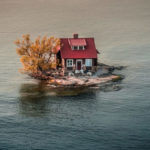
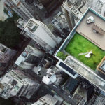
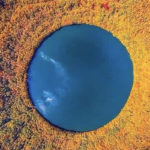
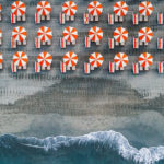
1 Hello, Tourists!
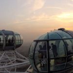
- Place: London, United Kingdom
- Height: 135 meters
If you thought you could enjoy the incredible view quietly and without being noticed, here it is obviously not a possibility. A drone is stationed next to this Ferris wheel and observes its passengers.
This is the London Eye, one of the most iconic structures in London. It has been open to the public since March 2000, and from the start, it has charmed everyone. After all, having a 360° view of the city from 135 meters high is incredible!
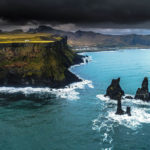
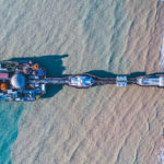
2 La Jument Lighthouse
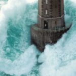
- Photograph: Jean Guichard
- Place: Sea of Iroise, west Brittany, Ouessant, France
This picture by French photographer Jean Guichard was taken on Thursday, December 21, 1989. In it, we can see the guard Theodore Malgorne standing in the doorway of the La Jument Lighthouse during a heavy storm.
La Jument Lighthouse was built in 1911 on a rock also named “La Jument” (“The Mare”, in English), about 300 meters off the coast of Ushant Island. It is 48 meters high, and since 2017, it is classified as a historical monument.
3 Mir Mine, Siberia
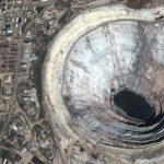
- Place: Mir mine, Siberian tundra
- Fun fact: This is the largest excavated mine in the world. The diamond deposits were discovered in 1955 by a team of Soviet geologists.
The Mir mine, also called Mirny mine, is located in the town of Mirny, in Sakha Republic, in the Siberian region of eastern Russia.
Two years after its discovery, the mine began to be exploited, and activities have never stopped since. A quarter of the world’s diamonds come from this mine, which is 1200 meters in diameter and 525 meters deep.
4 Spying On The Neighbors

- Warning: We don’t know if this man is aware of it, but his neighbor spies on him when he is on his balcony
- Just chilling: We doubt that he is aware of this, otherwise he would clearly not seem so calm
Nowadays, with cell phones that can take pictures as beautiful as a professional camera, and with the great accessibility of drones, nobody is safe from being spied on by a foreign pu.
When you think about it, it’s a bit worrying, isn’t it? Everyone has a right to privacy, especially when they are at home. When we are outside on our balcony, we are aware that neighbors can see us, but it is only a matter of respect that we do not take pictures or film people without their knowledge!
5 Dubai During Lockdown
- Photograph: Bachir Moukarzel
- Place: Dubai, United Arab Emirates
Lebanese photographer Bachir Moukarzel has been practicing aerial photography since 2014. This photo is from his latest project entitled “The lockdown-Dubai”.
This project went viral on social networks, so much so that it was featured on CNN, Al Arabiya, BBC, and many other worldwide TV stations. This is a great way to gain visibility while keeping busy during confinement!
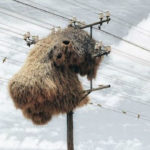
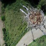
6 Stork Nest
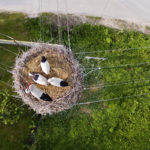
- Photograph: Szymon Pawlak
- Place: Poland
The idea to photograph this stork nest came to the photographer in 2013, but it wasn’t until 2015 that he finally took the picture with his drone. It is an extremely long process to plan a photo, don’t you think?
But the result is really very interesting. Who has ever had the chance to see the inside of a nest in real life? That’s the beauty of aerial photos; they allow us to see things from another angle!
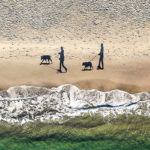
7 Aggressive Seagulls

- Did you know: Seagulls have a tendency to attack humans when they come too close to their nests.
- Protective parents: Gulls are extremely protective, especially during the bird nesting season.
These people just wanted to indulge in one of their favorite hobbies: climbing. However, rock climbing is not like climbing indoors; it involves being in the wild, among wildlife.
Without knowing it, it is not impossible that these people ventured too close to a seagulls nest, and the birds felt very threatened. After all, they can’t know what these people are doing there, maybe they came to steal the eggs!
8 Look Behind You!
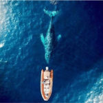
- What happened: A huge whale followed some sailors during 15 minutes.
- Aborted danger: The whale was friendly and the sailors didn’t even noticed they were followed!
One wonders if, afterwards, the sailors were disappointed not to have seen the whale behind their boat or if, on the contrary, they were frightened? After all, it must be scary to see a whale twice as big as your boat following you so closely!
Nevertheless, the scene gives a very impressive aerial photo, and fortunately, there was not even any fear, so even less harm!
9 Swimming With Turtles
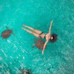
- Where are the sea turtles found: They are found in all oceans except the Arctic Ocean
- Did you know: All species of sea turtles are vulnerable or threatened
There are several protection or restoration plans to save sea turtles, but unfortunately, pollution, poaching and by-catch in fishing gear are accelerating their extinction. Really, how sad is that?
In more detail, there are a total of 7 species of sea turtles; three are classified by the IUCN Red List as either “endangered” or “critically endangered”, three others are classified as “vulnerable”, and the seventh has the classification “data deficient”.
10 Nose Picking

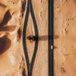
- Place: Engenheiro Aristides Milton street, in Salvador, Bahia, Brazil
- Fun fact: According to an old study from 1995, 91% of the participants said they were picking nose.
This man was quietly driving his little red car when an indomitable urge to pick his nose came over him. Clearly, he didn’t know that something was passing by and was going to immortalize this unglamorous moment!
However, we have some doubts about the shame that this man could feel to have been caught with his finger in his nose, because if we look at the image well, someone is in the passenger seat of his car! So this man has no qualms about picking his nose in front of others.
11 Lonely Predator
- Photograph: Bachir Moukarzel
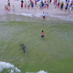
- Thought: One cannot help but wonder what this lion was thinking when he saw the drone above him!
Maybe he was thinking of a plan of attack! Or maybe he just thought it was a particularly exotic bird… It’s hard to put yourself in the shoes of a lion, after all!
Bachir Moukarzel is a native Lebanese photographer who lives in Dubai since 2002. He began exploring aerial photography in 2014, and he has since won several awards for these kind of photos.
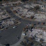
12 Bushfire
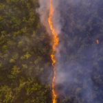
- Photograph: Robert Irwin
- Place: Cape York, Queensland, Australia
Robert Irwin is the son of the late Australian conservationist and film-maker Steve Irwin. At the age of only 17, he won the Natural History Museum’s wildlife photographer of the year people’s choice award with this image of a bushfire advancing through a woodland near the Steve Irwin Wildlife Reserve.
It is hard to imagine the fear of the people who were near this place. Nevertheless, one cannot help but find this photo absolutely beautiful and poetic. As if, sometimes, desolation can perfectly rhyme with beauty.
13 So Intrusive

- Did you know: Every year, since drones have become accessible to everyone, several complaints are made to the police to denounce ‘Peeping Tom’.
- Technically illegal: Obviously, it is illegal to fly your drone near buildings and people, but in the end, the police are powerless to stop them.
Imagine realizing that someone is filming you with his drone while you are in your daughter’s bedroom reading a story with her. It’s way too creepy! And imagine being filmed without even knowing it! In the end, it’s not impossible that it happens to you and you never know it!
We understand that we just have to close the curtains to be sure to keep our privacy, but still. When you’re at home, you like to feel free to do whatever you want without having to hide, right? What an incredible breach of privacy and intimacy, we are disgusted.
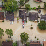
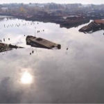
14 Tsunami Result
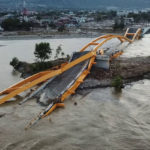
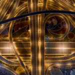
- Place: Sulawesi Island, Indonesia
- When: December 2018
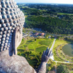
Indonesia was hit by a magnitude 7.5 earthquake on September 28, 2018. Then, three months later, on December 22, 2018, the Sunda Strait tsunami was generated from the area of Mount Anak Krakatau as a result of a volcanic flank failure.
The most significant damage was found on the west coast of Banten and on the south coast of Lampung. These two disasters left nothing but devastation behind.
15 Stonehenge
- Photograph: Copter Shot
- Place: Salisbury Plain, Wiltshire, England
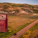
This photo was taken in December 2017 by Copter Shot, an aerial photography company that produces fine art photography prints. This mythical monument would have been built between 3000 BC to 2000 BC.
Everyone has at least heard of Stonehenge at one point or another. It is indeed considered one of the most famous archaeological sites in the world. It is also one of the most famous landmarks in England.
16 A silent killer
- Place: Phuket Island, Thailand
- Where the crocodile came from: He allegedly escaped from a nearby crocodile farm
It is easy to imagine how an animal can feel when it is stuck in a place it does not like. Imagine if it were you! It is, therefore, understandable that this crocodile wanted to escape from the farm where he was.
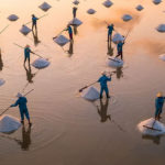
He must be so happy to be free at last! He begins a brand new and incredible adventure, after all! But one wonders where he was going to go. Does he have plans? Is he looking for travel companions, perhaps?
17 Solitary Living
- Photograph: Christoph Becker
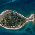
- Place: Saint Lawrence River, between Canada and New York
This small island situated in the Saint Lawrence River, more precisely in the Thousand Islands chain, in New York, United States, is called Just Room Enough Island, but is also known as Hub Island.
It is about 3,300 square feet and was purchased by the Sizeland family in the 1950s. With only one house, one tree, shrubs, and a small beach, it is the smallest inhabited island in the world.
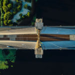
18 Hase the giant pink rabbit
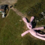
- Place: Piedmont, Italy
- Name: Yes, this giant rabbit has a name! Say hello to Hase, everyone!
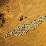
Haze made its appearance in Piedmont, Italy, in 2005. It was conceived and created by the Viennese art collective Gelitin. It took the collective 5 years to knit this giant pink rabbit, 200 feet long and 20 feet high.
Haze was supposed to last until 2025, but unfortunately, since 2016, it has already started to completely decomposed. In 2020, it seemed that only its outlines remained. As many found the rabbit rather creepy, one can imagine that few people feel sorry for its hasty decomposition.
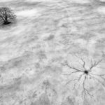
19 Ducks Unlimited Canada Logo
- Photograph: Ducks Unlimited Canada
- Place: Long Island, St. John River
The Ducks Unlimited Canada organization created the duck head, their official logo, in 1988 to celebrate its 50th anniversary in Canada. The piece is about the size of two soccer fields. That’s really huge!
The mission of this non-profit organization is to conserve, restore and manage Canadian wetlands and other natural spaces to preserve habitats for North American waterfowl, wildlife, and people. An important organization, to say the least!
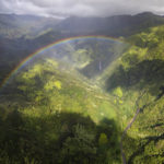
20 Fishing Boat
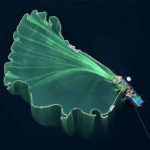
- Photograph: Trung Pham
- Place: Vietnam
This photo shows a fishing boat from a completely stunning angle! Who would have thought that a fishing boat could look so poetic? In fact, these fishing boats are called “basket boats” and are considered a very important part of the coastal Vietnamese communities.
Not only are they fishing boats, but they are also used as lifeboats in case of emergency at sea, or as lightweight transportation for cargo or people. There’s no doubt about it, these boats are literally essential to these communities!
21 Natural Pool
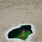
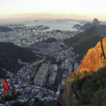
- Date: June 2019
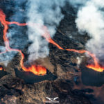
- Place: Danakil Depression, Ethiopia
We owe the photo to the New Zealand duo Expedition Earth. The Danakil Depression, the northern part of the Afar Triangle, is one of the hottest and lowest places in the world, lying 127 meters below sea level.
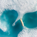
The Danakil Depression has several small salt lakes that formed after the Awash River dried up. There are also several hot springs. More commonly known as Dallol sulfur springs, they are widely studied to try to understand how life could arise on other planets and moons.
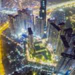
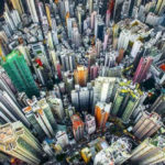
22 Pegasus Grounded
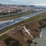
- Date: January 13, 2018
- Place: Trabzon Airport, Turkey
The Pegasus Airlines Flights 8622 went completely off the runway during its landing at Trabzon Airport, ending its fall just before diving into the Black Sea. Fortunately, no one was injured!
It was a domestic flight from Ankara, with a total of 162 passengers and 6 crew members on board. According to one of the pilots, the accident was caused by an engine that had a power surge.
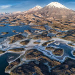
23 Weaving birds
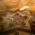
- Place: Kalahari Desert
- Bummer alert: No, it’s not a giant sculpture of a moose head, but rather the most famous bird’s nest in the world.
The photo was taken by a South African photographer. This nest would shelter hundreds of passerines. These birds being known for their maintenance skills, the nest can resist up to 100 years!
One of the reasons for the need for these very durable nests is that at birth, the chicks are altricial, thus blind, featherless and helpless. They therefore need extensive parental care, away from any danger.
24 Grass Bed
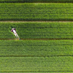
- Photograph: AmbroseLune
- Place: Xiwei Reservoir, Zoucheng, Shandong, China
The photographer looks so peaceful lying on his grass bed, taking a pretty nice selfie! It is possible to take absolutely amazing pictures with a drone, pictures that are out of the ordinary, that you could not take otherwise.
But using a drone to take a selfie is also a great idea, and this picture is really interesting. His Facebook profile picture must be very different from those of the average person!
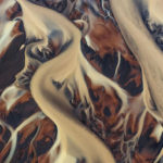
25 Rainbow Volcano

- Photograph: Michael Schirnhofer
- Place: Brennisteinsalda volcano, Iceland
The name of this volcano, found in the south of Iceland, means “sulphur wave” in English. It is the sulfur contained in the rocks of this Icelandic volcano that gives it all these magnificent colors.
This volcano is about 855 meters high and it is possible to admire it closely while hiking on the Laugavegur trail. Just in front of the volcano is an obsidian lava field.
26 The Guatemalan hole
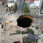
- Place: Guatemala City
- Cause: The tropical storm Agatha that hit the region in 2010
The hole is about 20 meters in diameter and about 90 meters deep. A three-storey building and an intersection were entirely swallowed up!
The disaster occurred on May 30, 2010 due to the tropical storm, but also because of the Pacaya Volcano eruption, and leakage from sewer pipes. Unfortunately, the risk of sinkholes in Guatemala City is very high and unpredictable.
27 The appearance of a clown
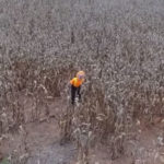
- Date: 2016
- Place: Huntsville, Alabama
This photo was taken over a field in Huntsville, Alabama. In 2016, several scary clowns were thus spotted in the most unlikely places. Something to make people nervous!
Apparently, it was a teenager who captured a video of this clown by chance while filming this cornfield with his drone. As the drone approached the clown, the latter started to run fast and hid in the nearby forest.
28 Angry Medieval Man

- When: 2016
- Place: Lipetsk, central Russia
A man tried to film the reenactment of a historical Middle Age battle with his drone during the International Festival of Historical Reconstruction of the Early Middle Ages “Rusborg” in 2016, but it didn’t go as expected.
A participant reacted in a very brutal way by destroying the drone by throwing a single spear at it. The reason for this rather intense reaction is unfortunately unknown, but one thing is certain, this man did not want to be filmed!
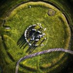
29 Crop Circle
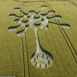
- Photograph: Stonehenge Dronescapes
- Place: Wiltshire, United Kingdom
This type of art is called crop circle. This is a shape created by flattening a crop, usually a grain, such as corn. This term has been used since the 1980s thanks to a man called Colin Andrews.
This one was reported on May 28, 2020. While many associate crop circles to obscure natural causes or aliens, there is no scientific proof of this. Crop circles would only be human creations.
30 Bright Blue Beach Water

- Photograph: Feather and the Wind
- Place: Lagoon of 7 Colours, Bacalar, Mexico
Feather and the Wind was created in 2015 by a couple from Montreal, Quebec, Canada. Wesley specializes in filmmaking and video editing, while Felicia is a travel writer and photographer.
The goal of their project is to help travelers live better experiences during their adventures around the world. So far, they have visited more than 20 countries on 4 different continents, and have edited hundreds of videos.
31 Alien Structure on Earth
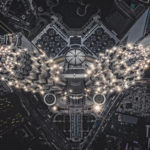
- Photograph: Tomasz Kowalski
- Place: Petronas Towers, Kuala Lumpur, Malaysia
The Petronas twin towers, designed by the Argentine architect César Pelli, have 88 floors and a total height of 452 meters. They were inaugurated in 1998 after 6 years of construction.
They are not the tallest skyscrapers in the world—they were from 1998 to 2004, tough, before being surpassed by Taipei 101, then by Merdeka 118 in 2020—but they are still the tallest twin towers in the world.
32 Picnic at Sea

- Photograph: Ryan Brown
- Place: Komiža, Croatia
The photo was taken on August 19, 2019 by travel photographer Ryan Brown on the sea by Komiža, Croatia. There is literally a full meal in these air mattresses! No wonder why this picture is called Picnic at Sea!
We really like this aerial picture taken with the help of a drone. It is colorful, festive and really gives off a picnic atmosphere on the water! These people must have spent a very nice afternoon on the water, taking a pleasant sunbath.
33 Cat Island
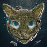
- Place: Unknown
- Dreaming: We don’t think a place like this actually exists, but it would be great, wouldn’t it?
All cat lovers would love to visit this original cat-shaped island! “Are you coming, darling? I’m going to swim in the cat’s left eye this afternoon! We could go and try the right one tomorrow?” Wouldn’t that be a dream trip?
In reality, this image is the work of the Parisian digital artist Fabien Barrau. While working in the advertising industry during the day, his pleasure, at night, is to capture images with his drone, then modify them with Photoshop to change our perception of the world.
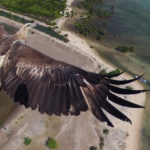
34 Humpback Whale
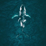
- Photograph: Tobias Hägg
- Place: Iceland
The humpback whale is one of the largest rorqual species in the world. They can measure 12 to 16 meters long and weigh between 25 and 30 tons. That is really huge! There’s a reason the photographer called this photo a “majestic encounter.”
The humpback whales also have a very distinct body shape thanks to their long pectoral fins and their knobbly head. They are therefore rather easy to recognize. Each year, they migrate up to 16,000 km from polar to tropical or subtropical waters to breed and give birth.
35 Plane Trees
- Photograph: Bruce Campbell
- Place: Portland, Oregon
Retired engineer Bruce Campbell bought this plane for $100,000 in 2009, once it was decommissioned. He then tow it into an Oregon forest in 2012, and renovated it into a house. Talk about an original and creative idea!
His project ultimately cost him hundreds of thousands of dollars, and required many hours of hard work. About his project, he once said, “My goal is to change humanity’s behavior in this little niche.” Some people spend their retirement differently than others!
36 Gulliver the Gentle Giant
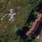
- Place: Edinburgh, Scotland
- Fun fact: The statue, called Gulliver the Gentle Giant, was created by Jimmy Boyle, a former gangster and convicted murderer, while he served a sentence at Barlinnie Prison in Glasgow.
The 100 feet long statue became so popular that in 1976, it was placed and unveiled. Composed of a torso, two arms and two legs, the statue formed a series of tunnels and hideaways. Unfortunately, it was demolished in 2011, leaving no trace of its past existence. But at one point, it was the largest concrete sculpture in Europe!
37 Please Welcome The Bride And Drone
- Photograph: Brandon Li
- Place: Hong Kong
One could easily believe that this photo is actually part of a wedding photo shoot, don’t you think? Isn’t that the first thought that came to your mind when you saw it? However, this photo was totally taken by accident!
Travel filmmaker Brandon Li and his friends were testing their new drone over the city and photographed these newlyweds totally by mistake as they took a few last pictures before putting their drone down. The photograph then tried to find the couple to offer them the picture. After all, it is an absolutely perfect wedding photo!
38 Unlucky for Some
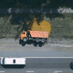
- Photograph: Ilya Martyanov
- Place: Russia
As it is often said, the misfortune of some makes the happiness of others. Clearly, the driver of this truck is having a very bad day, but the photographer has the chance to immortalize a very impressive scene.
The photographer said she saw the truck in this position near her home, so she rushed to get her drone to capture this amazing moment. How lucky for her to have stumbled upon this scene completely by accident!
39 Hurricane Harvey
- Photograph: MARCUS YAM
- Place: Houston, Texas
It was in August 2017 that Hurricane Harvey, a Category 4 hurricane, hit Texas and Louisiana hard, raging for 18 days, causing catastrophic flooding and about 100 deaths. Damage was estimated at $125 billion.
At the time, Hurricane Harvey was considered the costliest natural disaster recorded in Texas. It was the first major hurricane to make landfall in the United States since Wilma in 2005. It was also the wettest tropical cyclone to hit the United States, with peak accumulations of 60.58 inches.
40 A New York Christmas
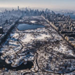
- Photograph: Bryan Dumas
- Place: Central Park, New York
This view of snowy Central Park is quite magical! The photographer particularly excels in taking pictures that communicate a story, emotions and perspectives. He has been perfecting his art since the age of 11.
Central Park covers an area of 843 acres, making it the 5th largest park in New York City. Not only it is the most visited urban park in the United States, with approximately 42 million visitors each year, but it is the most filmed location in the world!
41 Science Fiction?
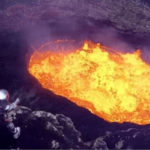
- Photograph: Sam Cossman
- Place: Active Marum crater, Oceania
The Marum crater is located on the volcanic island of Ambryn, in the Malampa province, in the Vanuatu archipelago. At this place, there are several lava lakes, and two craters near the top, which rises to 1,334 meters.
This place is so hot that several drones were destroyed while trying to capture a picture of this volcano. It’s better not to play with fire, but not with lava either! Following its last fissure eruption on December 16, 2018, however, the lava lake at Marum crater disappeared.
42 Falling Drones
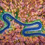
- Photograph: Calin-Andrei Stan
- Place: Bogata Forest, Romania
This photo is part of a series of drone photography entitled “Infinite Road to Transylvania”. In this series, the photographer explores the various winding roads of the region. There are even 3 other versions of this same photo, taken in summer, winter and spring.
Calin-Andrei Stan is a Romanian professional photographer living in Bucharest who specializes in aerial photography. Since 2017, he is an official photographer for National Geographic and National Geographic Traveler Romania.
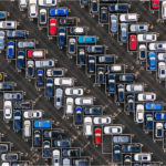
43 Have a good week!
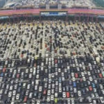
- Place: Hong Kong border, Beijing-Hong Kong-Macau Expressway
- Fun fact: The worst traffic jam ever recorded there happened in 2010 and lasted 12 days, with some motorists only able to travel less than one mile per day.
The Beijing-Hong Kong and Macau Expressway, more commonly known as the Jinggang’ao Expressway, is 2,272.65 km long and links the cities of Beijing and Shenzhen.
With more than 1.42 billion people in China, it is not hard to believe that such traffic jams can occur, despite a 50-lane highway!
44 Red Umbrella
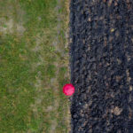
- Photograph: Cezar Gabriel (Caesarpmr)
- Two Worlds: This picture seems to represent the limit between two completely different worlds!
In fact, according to the photographer, this photo symbolizes the transition from rural to urban areas, with the red umbrella acting as an in-between stage. We must admit that the contrast is quite striking!
Here is one thing that is very interesting about photography: the subject doesn’t have to be original or extremely elaborate. What is important in this photo, for example, is the composition of the image, the way it is cut in two, and the little addition of the red umbrella, which make it the work of art that it is.
45 The Silverdome
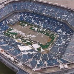
- Place: Silverdome, Pontiac, Michigan
- Fun fact: This now decrepit and abandoned stadium has already hosted the Super Bowl, a pope, the NBA final, an Elvis concert, and dozens of other world-class shows during its heyday.
The Pontiac Silverdome opened in 1975, and could seat over 82,500 spectators. Before the FedExField Stadium, located in suburban Washington, D.C., expanded in 2000, the Silverdome was the largest stadium in the NFL.
The Silverdome was once the official stadium of the Detroit Lions. It was purchased in 2009 by investors who were to turn it into a soccer stadium, but the project never came to fruition.
46 Christ The Redeemer
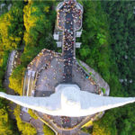
- Place: Mount Corcovado, Rio de Janeiro, Brazil
- Fun fact: The statue, which measures 124.7 feet high (including the pedestal), took 9 years to build.
Now an internationally recognized emblem of the city, the Christ the Redeemer was designed by the Brazilian engineer Heitor da Silva Costa and realized by the French sculptor Paul Landowski (with the help of the Romanian sculptor Gheorghe Leonida for the head).
Its construction was started in 1922 and finished in 1931. While the statue is of impressive height, one should not underestimate the width of its arms, which are 28 meters, and especially its weight, which amounts to 635 metric tons.
47 Six Flags Theme Park in New Orleans
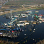
- Place: New Orleans
- When: September 2005
This Six Flags theme park, previously known as ‘Jazzland’ from its opening in 2000 to 2002, has been closed since Hurricane Katrina hit in August 2005. This picture was in fact taken about 2 weeks after the disaster.
The damage caused by Katrina was so extensive that the amusement park was never able to reopen. It can still be found near the intersection of Interstate 10 and Interstate 510, but several rides have been salvaged and relocated to other parks.
48 Basilica of St. Francis of Assisi
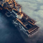
- Place: Basilica of St. Francis of Assisi, Umbria, Italy
- Did you know: The basilica has been a UNESCO World Heritage Site since 2000.
Studies have revealed that the construction of the basilica began in 1228. It consists of two churches and a crypt that houses the remains of St. Francis. Two earthquakes occurred in rapid succession in the area around Assisi on the morning of September 26, 1997, their respective magnitudes being 5.7 and 6.0.
Much of the cycle of frescoes of the life of St. Francis by Giotto, which are in the Upper Church, were slightly damaged, but the sections of the vault of the basilica, which collapsed due to the aftershock, were almost completely destroyed. The church was closed for 2 years for restoration.
49 Alone in the Desert
- Photograph: WhoSane
- Place: Al Qudra Desert, United Arab Emirates
Trees are a rare commodity in the desert, so it is important to give them priority. In this case, splitting a road in two to get around them was a natural choice, they didn’t even have to think about it!
Did you know that the Al Qudra desert has several lakes? These are man-made lakes, and they come in all styles. For example, there is the Flamingo Lake, The Last Lake, the Expo Lake, the Love Lake, and the most recent one, the Crescent Moon Lake.
50 Staten Island Boat Cemetery
- Place: Staten Island Boat Cemetery, New York
- Did you know: Founded in the 1930s, The Arthur Kill Ship Graveyard was used to place ships damaged during World War II.
Originally, the boats were simply to be placed there while they were dismantled to resell their parts, but obviously, the plans have changed. The location was even officially named in 2014. So it is now the Dungeon Iron and Metal Scrap Processing Facility.
The place, which contains abandoned vessels, mostly cargo ships and tugboats of the 20th century, is considered an “accidental marine museum”. We can find there the submarine chaser USS PC-1264, the very first US Navy Ship of World War II to have a predominantly African-American crew.
51 Drones of Dubai
- Place: Dubai
- Did you know: Dubai has created one of the most spectacular city skylines on the planet.
Dubai has, without a doubt, one of the most impressive skylines in the world. Any picture of this city is impressive, really, but a picture taken with a drone is even more breathtaking!
More than 3 million people live in Dubai, the most populous city in the United Arab Emirates. It’s crazy to think that at the end of the 19th century, Dubai was still a modest and isolated town living mainly from pearl fishing!
52 Country Colors
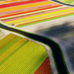
- Photograph: Anders Andersson
- Place: Netherlands
This photo of a tulips field with its diverse and vivid colors is absolutely beautiful. The division between the various colors and between the ground and the rivers seems too perfect to be true.
Anders Andersson is a freelance journalist and photographer based in åled, Sweden. He mainly shoots editorial subjects such as news, portraits and reportage, as well as weddings for magazines and newspapers.
53 The Day’s Catch
- Photograph: Curtis Williams
- Place: Panama City Beach, Florida
Can you imagine how scared the lady was when she saw the shark? Fortunately, she was more scared than hurt! Maybe she didn’t even have time to see it? We hope so, otherwise, what a fright!
Seeing all the people who have taken refuge on the beach and are watching her, it almost looks like she is actually trying to approach the shark on purpose… It also looks like her boyfriend would love her to get out of the water!
54 Frozen Rivers
- Photograph: Max Foster
- Place: Delta River, Iceland
This photo of the icy rivers of Iceland’s winter mountains by abstract aerial photographer Max Foster was taken at an altitude of 1,500 feet. Iceland is known for its breathtaking ice scenery, but here we find a very interesting perspective.
This photo is part of a series called Elemental, which was dedicated to abstract aerial photography of the nature that is all around us, and be sure that all the pictures in this series are as spectacular as this one!
55 Docked Barges

- Photograph: JP and Mike Andrews
- Place: Warwickshire, UK
The Andrews brothers love to immortalize the order and symmetry of the world around us by offering us abstract aerial shots. The caption on this photo reads “The point is not to work out what it is, but to show how weird and wonderful the world can look from above.”
The Andrews brothers travel the world in order to photograph it from a different angle, and to show it to us in a new light, from their always stunning abstract point of view. Their Instagram account, @abstractaerialart, has over 130K followers.
56 Harvesting Grass
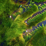
- Photograph: Tuan Nguyen
- Place: Vietnam
Every year, in August, it is the season of the grass harvest in Vietnam. A farmer is able to cut about 300 bundles of grass per day. These bundles are then sold and used by people in the West to create handicrafts, like knitting cushions, hats, or baskets.
The harvested grass is also increasingly bought by shops who use grass stalks with a diameter larger than 4 or 6 millimeters to replace plastic straws. It could be a very ecological long-term solution to help save our planet.
57 El Nino – Bad Boy
- Photograph: Duncan Sinfield
- Place: California
El Niño is a meteorological phenomenon that causes heavy rains and landslides, promoting coastal erosion. They occur irregularly, at intervals of 2 to 7 years, mainly between October and March in North America.
In the United States, when the effects of El Nino are felt, wetter-than-average conditions are generally found along the Gulf Coast between Texas and Florida, while Hawaii, the Ohio Valley, the Pacific Northwest and the Rocky Mountains experience drier conditions.
58 Californian Catastrophe
- Place: California
- When: October 2017
In October 2017, the Tubbs Fire, the most destructive wildfire in California’s history, began, ravaging more than 5,600 buildings. Nearly 37,000 acres of land were burned, and, tragically, at least 22 people were killed.
California is used to wildfires, but this one was different. It raged over a vast area of the state’s most costly conflagration. The Tubbs Fire, however, was only one of several dozen large fires that raged simultaneously in early October 2017 in eight Northern California counties. This situation has been named the “Northern California firestorm.”
59 World Cup Finale

- Photograph: Svetlin Marinov
- Place: Maracanã Stadium, Rio de Janeiro, Brazil
The Maracanã Stadium opened its doors in 1950 to host the FIFA World Cup on July 16 of the same year. It was also the venue for the opening and closing ceremonies of the 2016 Olympic and Paralympic Summer Games.
Owned by the state government of Rio de Janeiro, this stadium is now run by the sports clubs Clube de Regatas do Flamengo and Fluminense Football Club. “Maracanã” is related to the Rio Maracanã, a river in Rio de Janeiro now channeled.
60 As The Crow Flies
- Photograph: Dendi Pratama
- Place: Bali Barat National Park, Indonesia
Have you always wanted to know what the world around you looks like as the crow flies? Drones finally make it possible! And here, the photographer has taken the expression in its literal sense.
Established in 1995, the Bali Barat National Park covers a territory of 190 square kilometers and has a very diverse wildlife. Indeed, it is home to over 160 animal species, mammals as well as birds and reptiles.
61 Symmetrical parking lot
- Photograph: JP and Mike Andrews
- Place: North of England
This photo by the Andrews brothers can be found in the book Eyes over the World: The Most Spectacular Drone Photography released in May 2020. Despite some empty parking lots, the symmetry is particularly impressive!
The Andrews brothers specialize in abstract aerial photography. They founded the company Aerial Abstract Art, and have been pursuing their passion since 2016. They don’t care what the subject of the photo is, as long as it is abstract!
62 Frightening Lightning
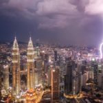
- Photograph: Pete DeMarco
- Place: Kuala Lumpur, Malaysia
The timing necessary to take this perfect picture is very impressive. The photographer is certainly a patient and meticulous person, especially when we know that, on average, a lightning strike is visible for less than a second!
Did you know that at its peak, a typical thunderstorm produces 3 or more strikes to the Earth per minute? And on average, on Earth, there are between 50 and 100 lightning strikes per second, or between 1 and 3 billion of flashes per year!
63 City by Night
- Photograph: Tuan Nguyen
- Place: Saigon, Vietnam
Founded in 1698, Saigon, whose real name is Ho Chi Minh City, is the largest city in Vietnam, occupying about 2,061 km2. The name “Ho Chi Minh City” was proclaimed in 1946, but was not officially adopted by the city until after the 1976 reunification to honor the Vietnamese revolutionary and politician Ho Chi Minh.
Ho Chi Minh City has a metropolitan population of about 21.2 million. It is the primary economic hub of Vietnam, but also an emerging international destination, receiving more and more tourists every year.
64 Lombard Street

- Photograph: Bryan Dumas
- Place: Lombard Street, San Francisco
Lombard Street is potentially one of the most famous streets in California, and it is proclaimed the “crookedest street in the world”. This street is a major tourist attraction, receiving about 2 million visitors per year.
It can also be seen in several movies during car chases, including Good Neighbor Sam (1964), Dr. Goldfoot and the Bikini Machine (1965), What’s Up, Doc? (1972), Magnum Force (1973), and Ant-Man and the Wasp (2018).
65 Rocky Coast
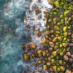
- Photograph: Jonathan Payet – Dronecopters
- Place: Réunion island
Réunion Island is, in fact, a volcanic island with a steep relief created by a very marked erosion. One of the volcanoes found on this island, named Piton de la Fournaise, is one of the most active volcano in the world.
Réunion Island, located in the Indian Ocean, holds the status of a region of France. The island is a total of 2,511 square kilometers and has a population of approximately 868,840 people.
66 Provence, Summer Trim
- Photograph: Jerome Courtial
- Place: France
This image was captured over a lavender field near Valensole, a commune in the Alpes-de-Haute-Provence department, in the south of France. The photo won first place in the Nature category of the 2017 International Drone Photography Contest.
While photos taken in a lavender field are very popular when looking for an elegant, romantic, or poetic shoot, this photo is very different from what we are used to seeing. Here is a new shot completely different, but just as splendid.
67 All The Roads

- Photograph: Bryan Dumas
- Place: Tom Moreland Interchange, Atlanta, United States
Complicated and massively intertwined road traffic interchanges of this type are called “Spaghetti Junctions”. The term was originally used in 1965 to refer to the Gravelly Hill Interchange on the M6 motorway in Birmingham, United Kingdom, and since then, it has been widely used.
In the United States alone, there are 19 Spaghetti Junctions. The state with the most is Nevada, with a total of 3. The Tom Moreland Interchange pictured here, which represents the interchange of I-85 and I-285 as well as Chamblee-Tucker Road and Northcrest Road in DeKalb County just outside Atlanta, is the only one in Georgia.
68 Winter Sports
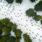
- Photograph: Jacek Deneka
- Place: Ski Racing Festival “Bieg Piastów” competition, Poland
For almost 50 years now, in March of every year, in Jakuszyce, Poland, the Bieg Piastów takes place. It is a cross-country ski race with several events, including the 10 and 50 km, and with thousands of participants.
The very first race of the Bieg Piastów competition was held on April 11, 1976. It was then 15 km long and 261 people participated. In 2009, the race had its highest number of participants, 1661.
69 The Great Buddha of Kamakura
- Place: Ushiku, Japan
- Built in: Around 1252
This statue is 120 meters high and was built to commemorate the birth of the co-founder of “True Pure Land School”, Shinran. It is one of the three tallest statues in the world, and it is designated as a National Treasure.
This large outdoor bronze statue of the celestial buddha Amitābha, one of the most famous icon of Japan, is located in the Kōtoku-in Buddhist temple. Being hollow, visitors can see the interior, which now contains many graffiti.
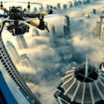
70 Overcoming The Fog
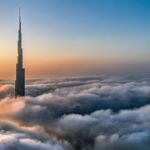
- Place: Dubai, United Arab Emirates
- Did You Know: The Burj Khalifa, a building 828 metres high, is the tallest building in the world.
The construction of the Burj Khalifa started in 2004 and was completed on January 17, 2009 in the heart of Downtown Dubai, a 2 km2 urban complex, real estate and architectural project created in 2000.
The Burj Khalifa would have cost the Emaar Real Estate Development Company a total of 1.5 billion US dollars, and it officially opened on January 4, 2010.
71 Water Lilies
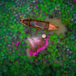
- Photograph: Thái Dương Lê
- Place: Mekong Delta, Vietnam
The water lilies of the Mekong Delta, especially the wild ones, are generally white, but for economic benefits, some plant dark pink ones.
Every year, the annual long-stemmed lily harvest takes place in the Mekong Delta in Vietnam. Water lilies have always been an iconic symbol of the country, and the harvest, which simulates a kind of dance mixing soft and sinuous movements, is considered one of the most romantic ceremonies in the world.
72 School Yard
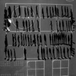
- Photograph: Tomas Van Houtryve
- Place: El Dorado County, California
Tomas van Houtryve decided to take a series of black and white shots with his drone accross America following the death in a drone strike of an elderly Pakistani woman in October 2012. His grandson said at a US congressional hearing in October 2013, “I no longer love blue skies. […] In fact, I now prefer grey skies. The drones do not fly when the skies are grey.”
So the photographer made it his mission to photograph, by drone, different types of gatherings mentioned in strike reports from Pakistan and Yemen, such as weddings, my funerals, or groups of people praying or training.
73 Bird Nest
- Photograph: James Junda
- Place: Frenchtown, Montana
In this photo, biologist James Junda is seen on the ground with his assistant Frederic Letourneux maneuvering his drone to capture the impending hatching of Osprey eggs in the nest.
It is increasingly common these days for nature experts of all kinds to use drones to help them in their work. After all, it’s the easiest way to observe the behavior of certain species of animals, among others, which often live high up in places less accessible to humans!
74 Little Town
- Photograph: Justen Soule
- Place: Dorothy, Alberta, Canada
The town of Dorothy, Alberta, Canada is in fact considered a hamlet—a small human settlement—and is virtually abandoned, and is practically abandoned. Indeed, its population is only about ten people. It is almost like a ghost town!
It is located in Special Area No. 2, a rural municipality consisting of one town, one village, 8 hamlets and several settlements. Special Area No. 2 has a total area of 9,195.06 square kilometers with a population of 1,860. The town of Dorothy was named after Dorothy Wilson, a young girl who lived in the area when the post office opened.
75 Colored View
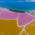
- Place: Las Coloradas, Yucatán
- Fun fact: The pink color of the water comes from the high presence of marine microorganisms containing beta-carotene, such as shrimp, algae and plankton.
Las Coloradas is located on the northern coast of the Yucatan Peninsula, right between the Gulf of Mexico and the lagoon Ria Lagartos. Nowadays, it is a very popular tourist attraction.
The Pink lagoon is in fact a man-made salt lake. For a few years now, it is forbidden to touch the water or the salt, but it is still possible to visit it and see it up close thanks to the guided tours organized.
76 A Sad, Apocalyptic Sight
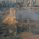
- Photograph: Hussein Malla
- Place: Seaport of Beirut, Lebanon
On August 4, 2020, a sad disaster occurred at the Port of Beirut when a large quantity of ammonium nitrate that was stored there exploded. The explosion resulted in at least 218 deaths, more than 7,000 injuries, and US$15 billion in property damage, leaving approximately 300,000 people homeless.
Specifically, a cargo of 2.750 tons of explosive substances had been stored in a warehouse of the port without adequate security measures. The explosion was so intense that the tremors were felt in Turkey, Syria, Palestine, and Israel, as well as in some parts of Europe. The detonation was even heard in Cyprus, more than 240 km away.
77 Beautiful Colors
- Photograph: Martin Sanchez – Zekedrone
- Place: USA’s East Coast
This photo perfectly captures the transition from summer to fall, commonly called “the fall phenomenon”. This is the moment when the trees that are still green and those that have started to change color are side by side.
This aerial view of a forest as fall approaches is absolutely breathtaking. We rarely get the chance to observe this from this angle. Thanks drones!
78 A Face In The Grain Field
- Photograph: Photographersworld
- Place: Grain field, Germany
This black and white photo really seems to show an aged face in a grain field, don’t you agree? The old man looks quite peaceful, with his long hair and beard in the wind, making this photo soft and poetic!
The photographer was really lucky to capture this shot at this exact moment. A few seconds earlier or later and the old man’s face would probably not be there!
79 In The Middle Of The Winter Forest

- Photograph: Photographersworld
- Did you know: This photo finished 7th in the Dronestragram 2018 competition.
Photographersworld definitely knows how to capture the most beautiful landscapes with his drone! This aerial view of a forest completely frosted in the middle of winter is absolutely breathtaking!
It is this type of photo that makes us realize how beautiful and majestic nature is. It is impossible to run out of beautiful landscapes to admire!
80 Salt Field
- Photograph: Trung Pham
- Place: Hon Khoi, Vietnam
In this picture, we can see men forming small salt dunes using wooden rakes. The Hon Khoi Salt Fields are a popular destination for tourists interested in the daily activities of local residents.
In itself, the Hon Khoi Salt Fields are not that impressive. What is admirable here is the beauty of the people who work there with passion and resilience. Covering about 400 hectares, Hon Khoi Salt Fields is one of the largest salt-making areas in Central Vietnam.
81 River by Candlelights
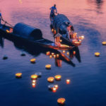
- Photograph: Tuan Nguyen
- Place: Nhu Y river, Hue City, Vietnam
The women in this picture are wearing Ao Dai dresses, a traditional Vietnamese dress. In Vietnamese spiritual culture, it is customary to place floating candles on the river to pray for peace and happiness.
Spirituality is very important in Vietnamese culture. Their beliefs being highly influenced by Confucianism, Taoism and Buddhism, many Vietnamese are convinced of the existence of things that humans cannot control, such as destiny, time, life after death, karma and reincarnation.
82 Reynisdrangar
- Photograph: Balazs Busznyak (Balazs3)
- Place: Iceland’s South Coast
Reynisdrangar are basalt sea stacks located in southern Iceland, under the Reynisfjall mountain. All around, there is a black sand beach that earned it a place in the top 10 most beautiful non-tropical beaches in the world in 1991. In 2021, it was rated the 6th best beach in the world.
Legend has it that the stacks forming Reynisdrangar came into existence when two trolls tried, unsuccessfully, to dragged a three-masted ship onto the land. When daylight came, the trolls became needles of rock.
83 A Fish Shaped island
- Photograph: Milan Photo
- Place: Gaz Island, Croatia
Gaz Island, also called Fish Island, is located in Croatia, in the Brijuni archipelago. This island is only 65,511 m2 and is uninhabited, and as hard as it may be to believe, its fish shape is totally natural!
Gaz Island is not the only unusual island to be found near the Adriatic coast in Croatia, quite the contrary. We also find the Huge fingerprint island, or Baljenac, in the Šibenik archipelago, as well as the Heart shaped island of love, or Galešnjak, found in the Pašman Canal. Their forms are obvious according to their names.
84 Straight Out of Heaven
- Photograph: Szabi Ignácz (Thedon)
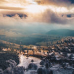
- Place: Bixad, Covasna, Romania
Bixad is a commune in Covasna County, Transylvania, Romania. Only 1,774 people live there, according to the 2011 Census. The Mikes Armin School and the Mikes Spas are the two tourist attractions of the place.
Although this Romanian commune is rather small and isolated, according to this gorgeous photo, its beauty is certainly worth the detour if you are in the area!
85 Desert Road
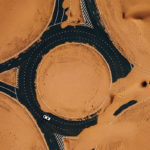
- Photograph: WhoSane
- Place: Half Desert Road, Dubai, United Arab Emirates
No matter how much we want to urbanize the space, nature reclaims its rights as it sees fit. This is the case at the wandering dunes of half desert road in Dubai, where the road tends to disappear under the sand of the desert which takes its place.
People who travel this road say they experience an unreal moment, as if they were suddenly in a post-apocalyptic situation worthy of a science fiction movie. The area tends to be quite busy, especially on weekends, with all the people camping and having a BBQ.
86 Brighton Pier
- Photograph: Luke Bell
- Place: Brighton Pier, England
Established in 1899, the Brighton Palace Pier is located in the center of the city of Brighton, opposite the Old Steine. It is the third pier built in Brighton, but the only one still in operation.
Brighton Palace Pier is 1,722 feet long and welcomes more than 4 million visitors per year. Brighton Pier remains very popular, and is even famous for its appearance in several British artistic works, such as the gangster thriller Brighton Rock, the comedy Carry On at Your Convenience and the Who’s concept album and film Quadrophenia.
87 Over the Bridge
- Photograph: Maxwebb
- Place: Pivdennyi Bridge, Kyiv, Ukraine
The Pivdennyi Bridge, also called “South Bridge”, was built between 1983 and 1990. It was designed by architect A. Gavrilov (“Mostobud”), and a group of engineers led by G. Fux. This bridge serves both the Syretsko-Pecherska metro line and road traffic.
With a total height of 135 meters, a width of 41 meters, and a length of 1,256 meters, the Pivdennyi Bridge has a total of 6 lanes, 3 in each direction, allowing to cross the Dnieper river.
88 3 Volcanos
- Photograph: Jonathan Payet – Drone copters
- Place: Réunion island
This aerial view of the 3 volcanoes erupting at the Piton de la Fournaise, on the Réunion island, is absolutely stunning. This volcano is currently one of the most active in the world. The most recent eruption took place on December 7, 2020.
About this picture, the photographer said, “I was up in the air just 16 hours after the eruption started—this happens about once a year. […] This one, though, is even more impressive, because we had four volcanic cones erupting at the same time, most of the time there’s only one.”
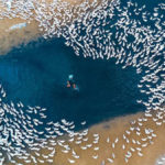
89 Flock of Sheep
- Photograph: Photographersworld
- Question: How many sheep do you think are in that flock?
A flock of sheep is already impressive from the ground, but from the air, it is even more spectacular! Sheep like to be close to other members of their flock. They may even feel stress when separated from other members. Usually, in a flock of sheep, the leader is simply the first sheep to start moving in a direction.
Did you know that sheep were one of the first animals to be domesticated for agricultural purposes? Sheep are raised for their fleeces, meat, and milk. Sheep’s wool is the most used animal fiber in the world!
90 Black Sand Beach

- Photograph: Balazs Busznyak (Balazs3)
- Place: Black Sand Beach, Reynisfjara
Iceland is known for its unique landscapes, and this black sand beach is no exception. It can be found on the south coast of Iceland, right next to the small fishing village of Vík í Mýrdal.
Reynisfjara is located about 180 kilometers from the capital, Reykjavík, and is considered one of the most beautiful non-tropical beaches in the world. National Geographic even named it in its top 10 in 1991! From this beach you can see the rocky sea stack Reynisdrangar.
91 Lot of Ice
- Photograph: Photographersworld
- Question: Would you be willing to go for a walk there?
This setting is particularly enchanting despite the danger that seems to emanate from it, don’t you think? A vast black, white and gray expanse with a single tree, a hole and several cracks in the ice!
The cracks in the ice already seem rather long, how far will this ice crack? Will they make it to the tree? This picture is very minimalist, but that’s what makes it so captivating and poetic!
92 Tea Harvest

- Photograph: Tuan Nguyen
- Place: Bao Loc, Vietnam
Vietnam is known for its various harvests. On this picture, we see a harvest of tea leaves. This harvest usually takes place in the morning, when the dew still remains on the leaves. On a harvesting day, usually hundreds of farmers are working to collect tea leaves to bring them to the factory for processing.
Bien Ho, a renowned tea estate, is one of the oldest in the Central Highlands province of Gia Lai. Indeed, the first plants were planted there by the French in 1921. Today, the tea estate is owned by the Bien Ho Tea Company, which grows 351 hectares of tea and over 700 hectares of coffee.
93 Mont Saint-Michel
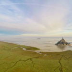
- Place: Mont Saint-Michel, Normandy
- Context: This photo was taken as part of the “Dronestagramme” travel photography competition by Wanaii Films.
Mont Saint-Michel is composed of leucogranite, which was solidified by an underground intrusion of molten magma about 525 million years ago. Every year, more than 3 million tourists visit this UNESCO World Heritage Site.
Mont Saint-Michel is about 0.97 square kilometers and has a population of about 30 people. The tide around the Mont varies by about 14 meters. In 2006, the Projet Mont-Saint-Michel was started in order to build a hydraulic dam and make the Mont Saint-Michel an island again.
94 Good Day On a Yacht
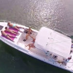
- What happens: A drone was flying over this large stretch of water when it happened to come across this yacht on which some women were tanning, topless.
- Question: How would you react if such a situation happened to you when you’re just enjoying the good times? Would you find it funny or would you be chocked?
Nowadays, the availability and low cost of good quality drones make our lives more risky, in a way. You never know when you’ll be spied on from above!
95 Jetty
- Photograph: Josh Welch
- Place: Amalfi coast, Italy
About this stunning image, the photographer wrote, “Always fascinated by the unique shapes used to try and separate man from the power of water and nature”.
The Amalfi Coast runs along the Tyrrhenian Sea and the Gulf of Salerno, south of the Sorrentine Peninsula and north of the Cilentan Coast. It is a popular jet set destination and has been a popular attraction for the European upper class since the 18th century.
96 Rainbow
- Photograph: Erez Marom
- Place: Kauai, Hawaii
Because of the really vast rainforest that covers it, the Hawaiian island of Kauai is nicknamed “Garden Isle”. With its 1,456.4 square kilometers, it is the 4th largest island in Hawaii, and the 21st largest island in the United States.
On the island of Kauai are the Waimea Canyon State Park and the Na Pali Coast State Park. According to the 2020 United States Census, the island has a population of 73,298 people.
97 Kraken Hole
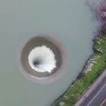
- Place: Lake Berryessa, California
- Fun Fact: It is, in fact, a unique spillway that is activated when the water level is too high. At that point, the water flows down this huge spillway to Putah Creek, about 100 feet below.
One can well imagine that it must be forbidden to go swimming in this body of water, because falling into this hole must not be pleasant!
Lake Berryessa is the largest lake in Napa County, California. This reservoir in the Vaca Mountains was formed after the construction of the Monticello Dam in the 1950s. It has provided water and hydroelectricity to the North Bay region of the San Fransicsco Bay Area since the 1960s.
98 The Boneyard
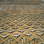
- Place: Tucson, Arizona
- Fun Fact: It’s the largest boneyard of its kind in the world. There are about 4,000 aircrafts there.
A boneyard is the place where planes that are no longer in use are stored. Most aircraft are either kept for maintenance or to retrieve parts that will be reused or sold before the aircraft is destroyed.
Located right next to the Museum at Davis-Monthan Air Force Base, the Pima Air & Space Museum offers exclusive bus tours of the Tucson Boneyard, also known as the 309th Aerospace Maintenance and Regeneration Center (AMARG).
99 Morrison’s Quarry
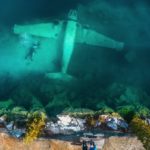
- Place: Chelsea, Quebec, Canada
- Bummer alert: The plane did not crash; it was placed there voluntarily, along with tugs and cars, to make the diving experience more enjoyable for the divers
Even if we know that the plane was placed there voluntarily, it must still be very nice to dive to see it!
Morrison’s Quary is typically used for scuba diving lessons and the Great Canadian Bungee, the highest bungee jumping point in Canada, but as of 2019, visitors now have access to an incredible hidden swimming hole with the clearest water in Ottawa. So clear, in fact, that you can see anywhere from 25 to 100 feet deep!
100 A Blue Hole
- Place: Andros Blue Holes National Park, Bahamas
- Fun Fact: Andros Island is the place with the most Blue Holes in the world, with 175 inland and 50 scattered around the shallow waters offshore.
The blue holes are, in fact, a submerged underwater excavation. They were formed during the Ice Age, when the sea level was about 100 meters lower than it is today.
The Blue Holes National Park of the Bahamas was established in 2002 and covers 162 square kilometers. The blue holes contain many unique cavefish and invertebrates.
101 Shadows
- Photograph: Yevhen Samuchenko (Qliebin)
- Place: Black Sea Beach, Bulgaria
The shadow of this couple walking their dogs on the Black Sea Beach in Bulgaria is really interesting, don’t you think? Their sizes is particularly impressive!
Black Sea Beach is also known as the Bulgarian Riviera. It covers the entire east coast of Bulgaria, stretching from the Romanian Black Sea resorts to the European Turkey, along 378 kilometers of coastline.
102 A Reckless Man
- Place: Rio de Janeiro, Brazil
- Fun Fact: The summit of the Morro dos Cabritos where this man is located is at an altitude of 1,257 feet.
People venturing to walk on a slackline at this location seem to be numerous. Note that you must not be afraid of heights, though, and you must be very confident in your security cable!
Morro dos Cabritos, or “The Goat Hill” in English, is located in the Parque Natural Municipal da Catacumba, near Copacabana. From there, it is possible to hike to the top, from where it is possible to contemplate different neighborhoods of the beautiful city of Rio de Janeiro.
103 Bubbling Up
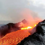
- Place: Iceland
- Thanks, drone: This picture couldn’t have been taken without a drone, otherwise the photographer’s life would have been in great danger!
In addition to having to position his drone to get the perfect shot, the photographer also had to make sure to keep his drone far enough away from the heat of the lava if he didn’t want it to melt in midair!
Iceland has about 30 active volcanic systems. The last major eruption occurred in 2021 near the mountain Fagradalsfjall, in the Reykjanes peninsula. The fissure through which the lava flowed grew from 200 meters long to 500 meters in just a few hours.
104 Drones and Divers

- Place: Yellow River, China
- Fun fact: The man on the picture is 60 years old and went diving over that waterfall to celebrate his birthday.
Di Huanran, the Chinese diver in the picture, is the Guinness World Record holder for the largest waterfall dive in the world. The sixty-year-old started his waterfall divings in his twenties, when he went to observe the Jingpo Lake Scenic Area.
It was when he saw the Diaoshuilou Waterfall that he felt like jumping down the cliff to know the feeling he would get. The man said, “I’ve been diving for 35 years. I feel delighted to dive every day. And I will keep diving, as long as my body allows.”
105 Bear from the Air
- Photograph: Florian Ledoux
- Place: Arctic ice caps
This photo is both spectacular and sad, as we see a polar bear walking on melting ice, the habitat of this majestic animal being in danger. Its current situation is considered vulnerable.
The average Arctic sea ice extent in 2022 is at its lowest. While the ice now covers 14.06 million square kilometers, it is still 630,000 square kilometers less than the average extent between 1981 and 2010. The Arctic spring melt is always significant, but unfortunately it is becoming increasingly so.
106 A nightmare in the sky
- Place: Hong Kong
- Fun fact: This region is where we find the largest number of skyscrapers in the world.
This aerial view of Hong Kong’s skyscrapers is absolutely beautiful, but unfortunately, they make life difficult for citizens by driving up housing prices. The total amount of skyscrapers in Hong Kong is 518. That’s a lot!
And all these skyscrapers are over 150 meters high. The second city with the most skyscrapers of at least 150 meters is Shenzhen, with a total of 343. To give you a better idea, New York comes in 3rd place, with 300 skyscrapers over 150 meters. That’s 218 less than in Hong Kong!
107 Feeding the ducks
- Place: Tuy Hòa, Vietnam
- Fun fact: Some 30 million ducks are raised each year in the country.
Vietnamese people raise ducks mainly for their meat, but also sometimes for their eggs. In addition, ducks are very useful to farmers as they feed on insects that damage rice in rice fields.
Tuy Hòa is the capital of Phú Yên province, in south-central Vietnam. This city is 107 square kilometers in size and has a population of over 200,000 people. The area has 2 mountains, Chóp Chài Mountain and Nhạn Mountain. At the top of the Nhạn Mountain is a Champa Temple from where one can admire a complete view of Tuy Hòa City.
108 Sur La Mer

- Photograph: Roberto Corinaldesi
- Place: Italy
Attracted to photography from an early age, Roberto Corinaldesi has won no less than 19 recognitions since 2017, and we have no trouble understanding why! This photo, entitled “Sur la mer” (“On the sea” in English), is absolutely stunning.
The dozens of people in this picture are so small that they almost look like ants swimming in the middle of the sea! This aerial photo was really captured at the perfect moment, and it’s no surprise that even years later, it still wins awards.
109 Soccer Field
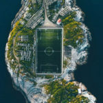
- Photograph: Michael Schirnhofer
- Place: Henningsvær, Norway
Henningsvær is a small town in Norway known for its fishing, but also for its love for soccer. It’s not hard to believe when you see that the soccer field takes up about half of the island’s surface! They don’t mess around when it comes to soccer.
The village of Henningsvær is only 0.3-square-kilometer, and as of 2018, 510 people lived there. Thanks to the growing popularity of drone photography, the Henningsvaer Fotballbanen (their soccer field) has gained worldwide attention.
110 Calm Beach
- Photograph: JP and Mike Andrews
- Place: Massa, Italy
This picture of the Andrews brothers is meant to show how “weird and wonderful the world can look from above”. Indeed, the perfection with which these chairs and parasols are aligned on the beach is impressive!
The photography duo absolutely hates it when people are in their photos, so like for this photo, they scouted the location, then waited for the right moment for no one to be there. Imagine the patience of these men!
111 Laguna De Cotacotani
- Photograph: Alex Mimo
- Place: Lauca National Park, Chile
Lauca National Park, situated in the far north of Chile, in the Andean range, is 1,379 km2 and consists of a mixture of altiplano and mountains, mainly huge volcanoes. Just south of this park is the Las Vicuñas National Reserve.
The main attraction of the place is undoubtedly the small lacustrine area formed by the lakes Chungará and Cotacotani, which are just at the foot of the Payachata volcanic group.
112 Fascinating Fortifications
- Photograph: Amos Chapple
- Place: Fort Bourtange, Holland
The construction of Fort Bourtange was completed in 1593. It was originally intended to control the only road connecting Germany to the city of Groningen, which was once controlled by the Spaniards during the time of the Eighty Years’ War.
In 1851, the fort was converted into a village, but living conditions began to deteriorate. In 1960, the local government decided to halt its decline by restoring the old fort to its 1740s-50s appearance, and Fort Bourtange now serves only as a historical museum.
113 Wandering Field
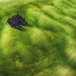
- Photograph: Mauro Pagliai
- Place: Tuscany, Italy
In this picture, we can admire the green fields of a Tuscany region of Val d’Orcia with, in the middle, a grouping of cypresses trees. What a wonderful view! Tuscany is actually a region in central Italy of about 23,000 square kilometers. Its population is of about 3.8 million inhabitants.
The region is obviously known for its beautiful landscapes, but also for its history, its artistic heritage and its influence on high culture.