USA Maps That Will Totally Change How You See The Country
1 Salary Needed To Buy A House

Buying a house is a huge deal for both financial reasons and for a sense of security. For most people, buying a house is a goal they would like to accomplish at some point in their life. However, buying a house can be incredibly difficult depending on where you live.
This map shows the salary you would need to afford an average home in the state where you live. In California and New York, an incredibly high salary is necessary, as property prices are significantly more than they are in other parts of the country. On the other hand, buying a house in West Virginia would only require a salary of just over $38,000. With that in mind, it might be time to make a move to West Virginia.
2 Second-Largest Religion
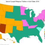
Christianity is easily the most dominant religion in the United States. In fact, it’s the first most practiced religion in all 50 states. However, there are plenty of religions besides Christianity, and many of them are practiced across the country.
This map shows that Buddhism has a strong following in the US, particularly on the West Coast. However, in the southern states and much of middle America, Islam is the second most widely practiced religion. On the East Coast, Judaism dominates religious practices. A couple of states also practice Hinduism, though it’s less common than the other religions.
3 USA Summary
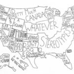
This hilarious map shows what most people think about the states across the US. As you can see, most of the northern part of the USA is considered “pretty much Canada,” while Alaska is simply considered “other Canada.”
The entire South is just known as “stereotypes” and New Mexico is best known for the hit TV show Breaking Bad. In addition, much of the East Coast is simply known as “rich,” while the West Coast is best known for Hollywood. If you had to sum up the entire USA, we have to admit this map does a pretty good job.
4 Name For Sweet Carbonated Beverages
The US is so large that it’s hard to agree on much, including what we should call sweet carbonated beverages such as Coca-Cola, Dr. Pepper, and other sodas. The most common names are “soda”, “pop”, and “coke”, and the term used varies from region to region.
On much of the west and east coasts, people call these carbonated beverages “soda”. However, in the northern half of middle America, “pop” is the preferred term. If that sounds weird to you, consider that Texas and other southern states refer to all sweet carbonated beverages as “coke”. While that may seem confusing to many, it’s perfectly normal for them.
5 Depression Diagnosis
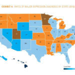
Mental health has become an increasingly important issue over the years. As talking about mental health and seeking out treatment becomes more common, more and more people are diagnosed with mental health issues, such as depression. Interestingly enough, the rates of depression also vary from state to state.
This map shows the distribution of major depression diagnoses in each state. States like Oregon and Washington have fairly high rates of depression, which could be due to their dreary, rainy weather. Utah, Minnesota, and Maine all have the highest percentage of depression diagnoses. On the other hand, Hawaii has the lowest percentage. It’s probably less likely that you’ll be depressed when you’re living in a tropical paradise.
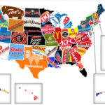
6 Famous Brands
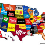
The US is full of innovation and each state has its claim to fame. Some brands were born on US soil, while others are manufactured here and sold across the country. This map shows the most famous brand from each US state.
California is, of course, represented by Apple since the company’s founder, Steve Jobs, hails from Palo Alto. The first Starbucks opened its doors in Seattle, Washington, which is why the state is best known for that brand. From Nike to Coors or to Coca-Cola, each state has a brand, and they can all be found on this map.
7 Natural Loudness
You can create a map of the US using almost anything, including just how loud each state is. But this map doesn’t judge a region of the country based on its bustling cities. Instead, the map measures the noises in the wind in decibels. The resulting number is considered natural loudness and encompasses noises from birds, lakes, streams, the wind itself, and any other naturally occurring sounds.
As you can see on the map, the western region of the US is significantly quieter than the Eastern region. In fact, the loudest areas of the country seem to occur right in the middle. While many think of the West Coast as busy and always moving, the East Coast is naturally much louder.
8 Largest Coffee Chain
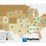
If you feel like there’s a Starbucks on every corner where you live, it’s probably because there is. This map shows the largest coffee chain per state, which overwhelmingly across the US is Starbucks. It’s only on the East Coast that Dunkin Donuts outpaces Starbucks.
In states like Washington and Oregon, there are anywhere from 20 to 28 Starbucks shops per 100,000 population. That means there might actually be a Starbucks on every corner. But what can we say? Americans love their Starbucks.
9 Density of Karens
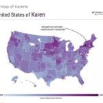
Karens can be found anywhere, anytime. The term “Karen” refers to middle-aged women who are typically entitled, pushy, and demanding. While Karens are scattered across the US, this map shows that Karens may be more common in certain areas rather than others.
According to this map, Karens are especially dense on the East Coast. They can also be found quite easily in Minnesota. In comparison, Texas and the northern USA don’t have many Karens. If you’re a service worker in one of those states, you can breathe a sigh of relief.
10 Weather
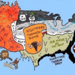
If you want to know what the weather is like across the US, this map has the answers. Well, sort of. The map does tell you what the weather is like, but it mostly boils everything down to stereotypes.
While the West Coast can actually be quite cold and rainy during many months of the year, this map simply describes the weather as “on fire.” On the other hand, the entire south apparently has “air made of hot soup.” Perhaps most funny, however, is the weather in Alaska, which just reads, “Bears only.”
11 Speed Limit
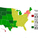
Overall, across the country, the speed limit on major highways is fairly similar. However, states are able to individually decide on the speed limits for their major roads. While most states play it safe with a maximum speed limit of about 70 mph, other states are fine with their drivers putting the pedal to the metal.
As seen on this map, some states—including Nevada, Idaho, and Oklahoma—have a maximum speed limit of about 80 mph. Beyond that, a small piece of Texas has the highest maximum speed limit at 85 mph. If you’re ready to test your road skills, Texas is the best place to push the limits of how fast your car can safely go.
12 Distorted By Population
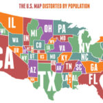
If you’re looking at this map and wondering about the odd proportion of the states, don’t worry—your eyesight isn’t failing you yet. Instead of a regular map of the US, this map is distorted by the population of each state. States with a larger population appear bigger, while states with a small population may be little more than a dot.
Due to their large populations, California, Texas, and Florida all appear quite large on this map. In comparison, Wyoming, Idaho, and Nebraska are all teeny-tiny. Some surprising states with larger populations include Illinois, Ohio, and New Jersey, which are all shown much larger than they are on a normal map.
13 Certified Organic Farms
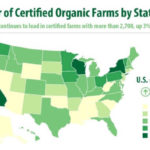
Organic food has become all the rage in recent years. Rather than eating foods covered in harmful pesticides, organic farmers raise their crops without the help of harmful chemicals. Of course, organic food is more important to some people in the US than it is to others.
California has a reputation for being very picky about its food and wanting everything to be organic. Apparently, the stereotype holds up, as California has more certified organic farms than any other state. In comparison, Nevada, Arizona, Oklahoma, and a few other states scattered across the country have little interest in certified organic farms. Still, they probably get their organic food from other farms across the country.
14 Where Half The Country Lives
The United States is quite a large block of land. While people live in various cities across the country, nearly half the population can be found in just 146 counties. This map shows those counties, and they’re almost precisely where you would assume they would be.
Much of the population exists on the coasts, particularly in California and New York. There is also a large chunk of people residing in Florida. Beyond that, the population is scattered in various states across the US, largely in big cities. That leaves a whole lot of room for the other half of the US population to live.
15 Seven Deadly Sins
This map takes a slightly different approach than the others in this list by using certain measures to determine how prevalent the seven deadly sins are across the country. The seven deadly sins are greed, envy, wrath, sloth, gluttony, lust, and pride.
Greed, measured by the average income compared to people living below the poverty line, is most prevalent in California, the East Coast, and Florida. Lust, measured by the number of STDs reported, can be found mostly in the southern states. If you want to determine which area of the US will most lead you into sin, just look at this map.
16 Largest Immigrant Population Birthplace
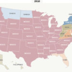
Immigrants are common across the US. After all, it was a country built on immigrants. While immigrants can come from all over, each state often has a dominant immigrant population from one country, as shown by this map.
As you can see, the large immigrant population in most states hails from Mexico. Near the northern border, immigrants from Canada are more common. Along the East Coast, you’ll also find many immigrants from China, El Salvador, India, and Jamaica.
17 Common Job Held By Immigrants
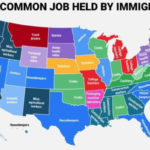
In addition to moving to the US, immigrants are also on the hunt for a job. This map shows the most common jobs immigrants hold from state to state.
On the West Coast, most immigrants make a living as agricultural workers. In states along the East Coast, however, they often work as housekeepers or home health aides. In the middle of the country, immigrants can hold a variety of jobs, from butchers to cooks or to construction workers. If you’re planning a move to the US, this map can help you determine where you should live in order to obtain desirable employment.
18 Major US Burger Chains
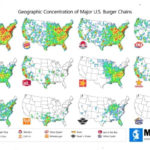
Sometimes you just need a good fast food burger. Thankfully, the US has plenty of chain restaurants that will fulfill your cravings. Of course, some are more popular than others. These maps show the concentration of some of the most well-known burger chain restaurants.
Unsurprisingly, McDonald’s is the most popular chain across the US, following closely by Burger King. Other brands, like White Castle or Whataburger, are only found in specific areas of the country. Steak N’ Shake is common on the East Coast, but has hardly any restaurants on the West Coast. The good news is, even if the chains are different, there’s always somewhere to buy a fast food burger.
19 Number of Major Sports Teams
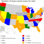
Americans love their sports, but not every state gets in on the action. While states like California have 19 major sports teams, other states don’t have any.
This map shows that New Mexico, Idaho, Maine, West Virgnia, and quite a few other states don’t have any major sports teams. Nevada, Oklahoma, and Kansas all have just one. On the other hand, Texas and Florida both have 10, with New York following close behind with an impressive 9. It’s clear the interest in major sports varies from state to state.
20 Highest-Paid Public Employees
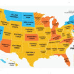
A public employee is someone who works for the government, whether on a state, local, or federal level. While this might conjure images of politicians or policemen, sports coaches are also on the list. Not only that, but they also make the most money in most states.
Across the US, football coaches dominate as the highest-paid public employees. They’re closely followed by basketball coaches. In fact, only a few states have highly paid public employees that are not sports coaches. Some other public occupations that lead to a high income are law school dean, medical school dean, and medical school plastic surgeon.
21 ‘Should I’ Google Question
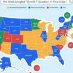
This fun map outlines exactly what people in each state are googling. The map shows the most common “should I” question people are asking across the US. For example, people in California are most commonly googling, “Should I move out.”
It seems many of the mid-eastern states are concerned about dieting and losing weight. On the other hand, people in Florida and New York are focused on their love lives. Perhaps most surprisingly, much of the population is simply wondering if they should vote in the next election.
22 What Your State Hates
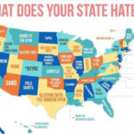
This map shows what each state hates the most across the country. Of course, the data is a bit limited. To fill this map, the creator drew from the dating app Hater, which matches people based on what they hate. While it might not be 100% accurate, it gives an interesting look into what each state dislikes most.
For California, fidget spinners are a major no-no. Coloradans, on the other hand, simply can’t stand *NSYNC. People in New York hate Times Square, while Oregonians can’t handle spin classes. Perhaps the funniest thing people hate comes from Idaho, where the entire population doesn’t like asking for directions.
23 Percent Who Guns
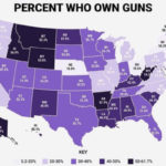
The gun debate is an ongoing struggle in the US, largely because so much of the population owns guns. If you’re not sure just how many people value their firearms, this map makes it clear.
In Montana, Idaho, Wyoming, Arkansas, and West Virgnia, more than 50% of the population owns guns. However, those states are the outliers. Across the rest of the US, about 30-40% of the population owns guns. The state with the lowest percentage of gun owners is Delaware, where just 5.2% of the population owns firearms.
24 Top Private Employers
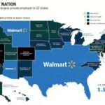
Walmart is overwhelmingly the largest private employer in most states in the US. Walmart employs 1.5 million people, making them the largest employer in 22 states.
Across the US, many of the other top private employers are universities. However, Boeing is the top employer in Washington, while MGM Resorts is the top employer in Nevada. Healthcare also claims a solid chunk of the states. Still, Walmart is the undisputed winner.
25 Best States For Driving
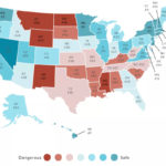
Considering most people across the US drive, knowing that your state is safe for vehicular traffic is pretty important. However, some states just aren’t as safe to drive in as others. Whether they have worse roads or crumbling infrastructure, there are some states where you just don’t want to take your car.
According to this map, the safest state to drive in is Maryland. On the other hand, Wyoming is the worst state to drive in. Surprisingly, California and New York, both known for their traffic, are actually considered fairly safe. Perhaps the constantly clogged streets meaning no speeding, leading to safer driving conditions.
26 Drunk Dining
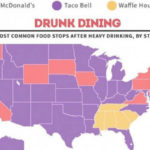
After a long night indulging in too many adult beverages, food is a must. But while some people satisfy their food cravings with a sweet breakfast indulgence from a 24-hour waffle house, others need something greasier to soak up all the alcohol.
According to this map, Taco Bell is by far the favorite drunk dining option across the United States. After all, what’s better than a Crunchwrap Supreme after a night of tossing back your favorite spirits? However, many coastal states prefer McDonald’s to satisfy their drunchies, while the southern states head to their closest 24-hour breakfast spot. While the preferences vary from state to state, the need for rich, overindulgent food after a night out is a common thread.
27 Iconic Fast Food Chain
Fast food can be found across the US. However, each state has a fast food chain that it’s known for. Whether it only exists in that state, the first shop was opened there, or it has simply become a favorite among the population, each state can be assigned an iconic fast food chain.
This map outlines the fast food chains associated with each state. Of course, California gets In-N-Out, as the restaurant was started there and was only available in that state for a long while. Blakes Lotaburger and Whataburger are most well-known in New Mexico and Texas, respectively. Other popular food chains that can be found across the US include Chipotle, Chick-Fil-A, Five Guys, and KFC.
28 Commonly Spoken Language
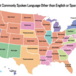
English and Spanish are two of the most common languages spoken around the US. However, the country is full of immigrants, which leads to states full of bilingual residents. If people aren’t speaking English or Spanish, what are they speaking?
According to this map, German is the next most common language spoken in states across the middle of the country. But while German is common in the middle of the USA, French is the dominant language along the East Coast. After that, a mix of languages are spoken across the rest of the country, including Tagalog in California, Nevada, and Hawaii, Navajo in Arizona and New Mexico, and Vietnamese in Washington, Texas, and Oklahoma.
29 Magnitude of the Largest Earthquake
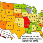
Some areas of the USA are more prone to earthquakes than others. For example, California and the entire West Coast are incredibly vulnerable to earthquakes, while many of the people living in states in middle America will never experience the dreaded shaking during their lifetime. Still, every US state has experienced an earthquake at some point, though some were worse than others.
According to this map of the magnitude of the largest earthquakes in the US, Alaska has experienced the worst shaking with a 9.2 magnitude earthquake. On the other hand, Maryland has experienced the mildest earthquake at a 3.7 magnitude. If you’re trying to decide where to live, knowing the states most prone to earthquakes could sway your decision.
30 Weirdest Food In Every State
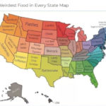
While some areas of the US are known for their amazing food, others don’t have a signature dish that everyone is dying to try. But all the states are equal when it comes to weird dishes they’ve created. From the sushirrito to clam pizza, each state has embraced its own unique and totally weird dish.
Some notable options include the green chile sundae in New Mexico. If you want a perfect mix of sweet and spicy, you’ll have to take a trip there. You can also eat rattlesnake in Texas or gator tail in Florida if you’re dying to dig into a reptile for dinner.
31 Average Debt Of University Graduates
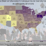
Graduating high school is a huge accomplishment, but it’s also a tricky introduction to the next stage of your life: college. While attending college isn’t required, it is a natural step for many following their high school graduation. Unfortunately, universities in the US are expensive, forcing many students to take out massive loans to make it through their four years on campus.
This map shows the average debt of university graduates across the US. States like Pennsylvania, New Hampshire, Rhode Island, and Connecticut all have the highest rates of debt at an average of about $35,000-$38,000. Coincidentally, this is also the area that boasts many expensive Ivy League schools. In comparison, Utah has the lowest average debt at just over $19,000.
32 Likelihood To Survive A Zombie Apocalypse
Some people across the US are genuinely worried about an impending zombie apocalypse. Well, if zombies do take over the world, this map lets you know exactly who across the country would survive.
While most of these dots seem rather random, it’s clear that most people in Texas and California don’t stand a chance against the zombies. However, most of middle America is apparently well-prepared for a zombie takeover. Perhaps we should take some tips from their bunkers.
33 Favorite Quarantine Activity
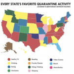
Everyone had to find a way to entertain themselves during quarantine. As with most things, the favorite quarantine activities people embraced depended on where they lived. This map has everything you need to know about what your fellow Americans were doing during quarantine.
According to this map, lucky Floridians spent their quarantine on the beach. Many of the southern states and California took a more relaxing approach to quarantine, spending much of their time binging Netflix and TV. Drinking was also another popular activity for many states across the country. A few, however, spent their time walking and hiking instead of gaining weight like the rest of us.
34 Where People Say Dang
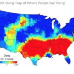
“Dang” isn’t a word that’s in most people’s vocabularies. Across most of the USA, people might say “dang” here and there, dependent on the situation. But this map shows that, in some parts of the US, “dang” is much more common than you might think.
This map shows that the southern states love using the word “dang.” Why? The map doesn’t say. But if you take a trip to the south, keep your ears peeled for a few dangs scattered amongst the population’s speech.
35 Cats Or Dogs
Cats or dogs? It’s a lifelong debate. While some are die-hard dog people, others appreciate the independence of cats and prefer to invite felines into their homes. As it turns out, cat and dog people can also be mapped across the US.
According to this map, the split between cat and dog people seems fairly even across the country. While Texas, New Mexico, and Louisiana are firmly dog states, those living in Oregon, New York, and Pennsylvania prefer cats. The distribution could also be due to the living conditions in each state. While homes in southern states tend to have more room, those living on the East Coast are oftentimes limited to smaller apartments, which makes it easier to have cats in their homes.
36 Commonly Spoken Language (Other Than Spanish)
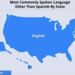
In case you don’t get it, this map is a total joke. There’s a lot of debate about how prevalent the Spanish language is across the US. In most states, it’s easily one of the most common languages.
However, there is one language that beats Spanish… English. If you’re worried that not enough people speak English in the US, you can breathe a sigh of relief. As this map shows, English is the most commonly spoken language across the entire US, especially if you don’t take Spanish into account.
37 Most-Used Word
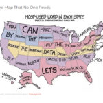
This map shows the most-used words in each state… or does it? When people see a map like this, they often glance over it before quickly moving on. But this map might have a little more to say if you take a closer look…
If you thought some of the “most-used” words were a little strange, that’s because they’re not the most-used words at all. Instead, the map takes advantage of people’s lack of attention to write an entire message across all 50 states. If you start at the top in Washington and read across to the right, you can decipher what the map has to say.
38 Homeless People
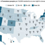
It’s hard to track the number of homeless people in each state as, for many of them, their situation is constantly in flux. However, the Department of Housing and Urban Development managed to create a map of homeless people across the US using data from a single night in January 2018.
As the map shows, states along the West Coast and New York, Vermont, and Rhode Island, all have high rates of homeless people. Middle America tends to have a lower number of homeless people per 10,000 residents. However, Colorado’s number is quite high for the region, and some randomly scattered states also have a higher population of homeless residents.
39 Most Remembered States
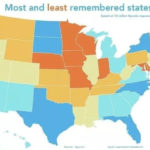
With 50 states to remember, it’s no surprise that some names stick out more than others. States like Florida, Texas, and California are easily remembered, even in other countries around the world. Unfortunately, not every state is so easily recognizable.
States like Missouri, Idaho, and Minnesota are easily forgotten. Other states that tend to slip people’s minds include Wyoming, Kansas, and New Hampshire. But they shouldn’t feel too bad: Some people even forget about Hawaii!
40 Noise Pollution
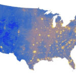
While natural loudness is one thing to consider, this map also points out noise pollution across the US. Unlike natural loudness, noise pollution does take into account human-made noise, such as the sounds associated with cities. With that in mind, the map changes slightly.
Rather than staying quiet, the areas surrounding big cities like Los Angeles, San Francisco, and Seattle have higher noise pollution. Still, the western half of the US is still significantly quieter than the eastern half. Much of the quieter regions of the US are filled with nature and deserts, so noise pollution isn’t quite as high.